| Sign In | Join Free | My chinacomputerparts.com |
|
| Sign In | Join Free | My chinacomputerparts.com |
|
| Categories | Airborne LiDAR System |
|---|---|
| Brand Name: | Hi-Cloud |
| Model Number: | ARS-1000L Airborne LiDAR System |
| Certification: | ISO, others upon the requests |
| Place of Origin: | China |
| MOQ: | 1 |
| Price: | Negotiable |
| Payment Terms: | T/T |
| Supply Ability: | 10 sets/month |
| Delivery Time: | 10 working days |
| Packaging Details: | Transport Case |
| Maximum Measurement Range: | 1350m @60% |
| Minimum Measurement Range: | 5m |
| Range Accuracy: | 15mm @150m |
| Angular Resolution: | 0.001° |
| Weight: | 4.5kg |
| Camera Resolution: | ≥42.4MP |
Long range of 1350m multi platform airborne LiDAR System ARS-1000L with 15mm@150m high accuracy
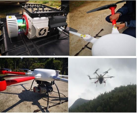
ARS-1000L airborne LiDAR system is a Riegl LiDAR based system which developed and built by Hi-Cloud. ARS-1000L airborne LiDAR system takes the UAV platform as the carrier. After several years of continuous iterative upgrading, on the basis of retaining the previous characteristics, its hardware architecture, processing performance, volume and weight, loading and unloading accessories have been comprehensively upgraded.
The system is widely used in emergency mapping, topographic mapping, power line inspection, highway survey, coastal reef survey, excavation and filling calculation, archaeological survey and mapping and other fields.
Main Advantages of ARS-1000L system
1. Under the measuring range of 150m, the ranging accuracy is better than 15mm.
2. The maximum range of LiDAR system is 1350m, and the system can operate normally even in the environment with large terrain drop.
3. The system integrates the 3D laser scanner, POS module and fan into the hardware architecture, which not only enhances the overall performance and stability of the system, but also compresses the volume to the extreme, and the overall weight is less than 4.5kg.
4. The small volume and weight of the system enable it to be well carried on various carrier platforms. It is not only suitable for mainstream multi rotor and VTOL fixed wing UAV, but also can be mounted on vehicle and backpack platforms for operation.
5. The whole system adopts the fast sliding structure design, and there is no gap between the rack and the system, which ensures the stability and reliability of the equipment.
6. The system also provides a proprietary lightweight anti-collision protective sleeve to provide certain physical protection for the equipment and reduce unnecessary damage to the equipment in some harsh environments and emergencies.
7. The loss prevention module is optional. After the UAV is lost, the equipment position can also be found to facilitate the search of equipment.
8. The laser emission frequency of the system is 750000 points per second. A higher point frequency means that it can better reflect the landform in the survey area and obtain more fine point cloud data.
Main Parameters of ARS-1000L system
| Items | Indicator | Parameter |
| System Performance | Absolute Accuracy | horizontal <5cm vertical <5cm |
| Weight | 4.5kg | |
| Storage | 1TB SSD | |
| Input Voltage | 20~30V | |
| Power Consumption | <75W | |
| Operation Temperature | -10℃~+40℃ | |
| Storage Environment | -20℃~+50℃ Humidity < 85% | |
| Laser Class | Class1 (eye safe) | |
| Laser Scanner | Maximum Measurement Range | 1350m @60% |
| Minimum Measurement Range | 5m | |
| Range Accuracy | 15mm @150m | |
| Repetition Accuracy | 10mm @150m | |
| Max. Effective Point Frequency | 750000 points/s | |
| Laser Gear for Adjustment | 6 levels | |
| Maximum number of received echoes | 4~15 | |
| FoV(selectable) | 0~330° 60°~90°airborne mode | |
| Scan Frequency(selectable) | 10~200 scans/s | |
| Angular Resolution | 0.001° | |
| POS System | Position Accuracy(post-processing) | Horizontal 0.01m Elevation 0.02m |
| Orientation Accuracy(post-processing) | Heading 0.010° Pitch/Roll 0.005° | |
| Camera System | Camera Resolution | ≥42.4MP |
| Camera Weight | <500g |
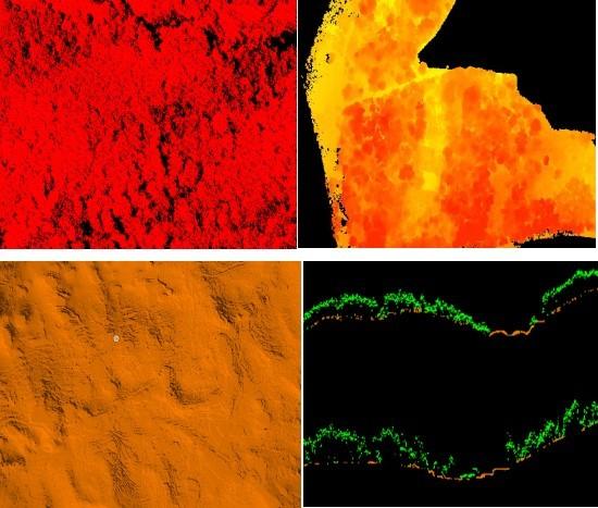
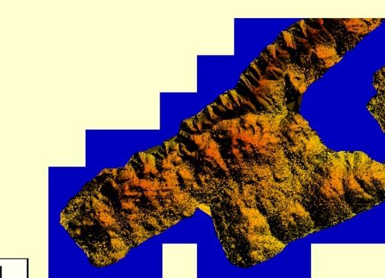
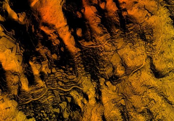
Pratical project of ARS-1000L system
Wind farm survey in mountain area
The survey area is mainly mountainous terrain. The average elevation in the wind farm survey area is high, and the altitude drop in some areas of the measurement area is over 300 meters. The whole wind farm covers an area of about 12 square kilometers. The vegetation is subtropical evergreen broad-leaved forest, with large vegetation coverage rate and various types.
The terrain of the survey area is complex, the altitude difference is large, the traffic is inconvenient, the climate environment is bad. There are several wind turbines with a height of more than 100 meters in the survey area, so it is difficult to design the route. The line of sight is blocked seriously, and it is difficult to locate the take-off point.
The project adopts ARS-1000L airborne laser measurement system. Three takeoff and landing points are selected in the whole survey area for a total of seven sorties.

|
